- 0 Shopping Cart

Kerala flood case study
Kerala flood case study.
Kerala is a state on the southwestern Malabar Coast of India. The state has the 13th largest population in India. Kerala, which lies in the tropical region, is mainly subject to the humid tropical wet climate experienced by most of Earth’s rainforests.

A map to show the location of Kerala
Eastern Kerala consists of land infringed upon by the Western Ghats (western mountain range); the region includes high mountains, gorges, and deep-cut valleys. The wildest lands are covered with dense forests, while other areas lie under tea and coffee plantations or other forms of cultivation.
The Indian state of Kerala receives some of India’s highest rainfall during the monsoon season. However, in 2018 the state experienced its highest level of monsoon rainfall in decades. According to the India Meteorological Department (IMD), there was 2346.3 mm of precipitation, instead of the average 1649.55 mm.
Kerala received over two and a half times more rainfall than August’s average. Between August 1 and 19, the state received 758.6 mm of precipitation, compared to the average of 287.6 mm, or 164% more. This was 42% more than during the entire monsoon season.
The unprecedented rainfall was caused by a spell of low pressure over the region. As a result, there was a perfect confluence of the south-west monsoon wind system and the two low-pressure systems formed over the Bay of Bengal and Odisha. The low-pressure regions pull in the moist south-west monsoon winds, increasing their speed, as they then hit the Western Ghats, travel skywards, and form rain-bearing clouds.
Further downpours on already saturated land led to more surface run-off causing landslides and widespread flooding.
Kerala has 41 rivers flowing into the Arabian Sea, and 80 of its dams were opened after being overwhelmed. As a result, water treatment plants were submerged, and motors were damaged.
In some areas, floodwater was between 3-4.5m deep. Floods in the southern Indian state of Kerala have killed more than 410 people since June 2018 in what local officials said was the worst flooding in 100 years. Many of those who died had been crushed under debris caused by landslides. More than 1 million people were left homeless in the 3,200 emergency relief camps set up in the area.
Parts of Kerala’s commercial capital, Cochin, were underwater, snarling up roads and leaving railways across the state impassable. In addition, the state’s airport, which domestic and overseas tourists use, was closed, causing significant disruption.
Local plantations were inundated by water, endangering the local rubber, tea, coffee and spice industries.
Schools in all 14 districts of Kerala were closed, and some districts have banned tourists because of safety concerns.
Maintaining sanitation and preventing disease in relief camps housing more than 800,000 people was a significant challenge. Authorities also had to restore regular clean drinking water and electricity supplies to the state’s 33 million residents.
Officials have estimated more than 83,000km of roads will need to be repaired and that the total recovery cost will be between £2.2bn and $2.7bn.
Indians from different parts of the country used social media to help people stranded in the flood-hit southern state of Kerala. Hundreds took to social media platforms to coordinate search, rescue and food distribution efforts and reach out to people who needed help. Social media was also used to support fundraising for those affected by the flooding. Several Bollywood stars supported this.
Some Indians have opened up their homes for people from Kerala who were stranded in other cities because of the floods.
Thousands of troops were deployed to rescue those caught up in the flooding. Army, navy and air force personnel were deployed to help those stranded in remote and hilly areas. Dozens of helicopters dropped tonnes of food, medicine and water over areas cut off by damaged roads and bridges. Helicopters were also involved in airlifting people marooned by the flooding to safety.
More than 300 boats were involved in rescue attempts. The state government said each boat would get 3,000 rupees (£34) for each day of their work and that authorities would pay for any damage to the vessels.
As the monsoon rains began to ease, efforts increased to get relief supplies to isolated areas along with clean up operations where water levels were falling.
Millions of dollars in donations have poured into Kerala from the rest of India and abroad in recent days. Other state governments have promised more than $50m, while ministers and company chiefs have publicly vowed to give a month’s salary.
Even supreme court judges have donated $360 each, while the British-based Sikh group Khalsa Aid International has set up its own relief camp in Kochi, Kerala’s main city, to provide meals for 3,000 people a day.
International Response
In the wake of the disaster, the UAE, Qatar and the Maldives came forward with offers of financial aid amounting to nearly £82m. The United Arab Emirates promised $100m (£77m) of this aid. This is because of the close relationship between Kerala and the UAE. There are a large number of migrants from Kerala working in the UAE. The amount was more than the $97m promised by India’s central government. However, as it has done since 2004, India declined to accept aid donations. The main reason for this is to protect its image as a newly industrialised country; it does not need to rely on other countries for financial help.
Google provided a donation platform to allow donors to make donations securely. Google partners with the Center for Disaster Philanthropy (CDP), an intermediary organisation that specialises in distributing your donations to local nonprofits that work in the affected region to ensure funds reach those who need them the most.

Google Kerala Donate
Tales of humanity and hope
Check your understanding.

Premium Resources
Please support internet geography.
If you've found the resources on this page useful please consider making a secure donation via PayPal to support the development of the site. The site is self-funded and your support is really appreciated.
Related Topics
Use the images below to explore related GeoTopics.
River flooding and management
Topic home, wainfleet floods case study, share this:.
- Click to share on Twitter (Opens in new window)
- Click to share on Facebook (Opens in new window)
- Click to share on Pinterest (Opens in new window)
- Click to email a link to a friend (Opens in new window)
- Click to share on WhatsApp (Opens in new window)
- Click to print (Opens in new window)
If you've found the resources on this site useful please consider making a secure donation via PayPal to support the development of the site. The site is self-funded and your support is really appreciated.
Search Internet Geography
Top posts and pages.
Latest Blog Entries
Pin It on Pinterest
- Click to share
- Print Friendly

Disaster Management Project for Class 9 – Complete Guide

Written By Avinash Sharan
Class 9 | projects 9, 13 comment(s), 10th may 2020, disaster management project.
It is mandatory to do a Disaster Management project for class 9 students every year.
According to CBSE, students studying in class IX have to submit a handwritten project on Disaster Management.
Topics will be provided by the school. The topic may be Natural Disasters or Man-Made disasters.
The purpose of giving this Disaster Management project to class 9 students is to make them prepared for any disaster.
Further, they can also spread awareness to the mass about the precautions to be taken at the time of National/Local Disasters.
Are you looking for a project on Tsunamis? Simply click the link https://shapingminds.in/project-on-tsunami/
To get the latest project on Sustainable Developmen t, click on the link.
“Project On Heat Stroke”- Understanding the Risks and Prevention
Things to be kept in mind while doing the project
Follow cbse guidelines strictly..
- Firstly, USE A-4 size file paper (one side ruled)
- Secondly, Use blue or black ink to write your project.
- Thirdly, design the cover page in such a way that it reflects your topic.
- Fourthly, write the Topic of the project, Name, Class, and Sec, and Roll no. on the cover page in bold letters.
- Use the bottom space for your Name, Class, and sec, Roll no.
- However, the project work should not be less than 15 pages (including the cover page)
- Be ready for Viva or written assignments based on your project.
- Utilize summer vacation / Lockdown time to complete your project.
- Lastly, do not use plastic covers.
Disaster Management Project Page-Wise With Subheadings
Sequence of pages: disaster management project .
will be your cover page with topics like
TOPIC: COVID-19 PANDEMIC IN INDIA and then show your creativity in designing the page.
Page No. 2:
Acknowledgment: (what should be written) see an example below.
Acknowledgment
From the core of my heart, I am very thankful to everyone who all supported me, for I have completed my project effectively and moreover on time. I am overwhelmed in all humility and grateful to acknowledge my depth to all those who helped me to put these ideas well. equally grateful to my ( NAME OF SUBJECT TEACHER ) for giving me moral support and guidance in doing this project. It would be an injustice if I do not thank my parents who helped me a lot in collecting data, pictures, and continuous help and support. With their able guidance, encouragement, and support, I could complete my project on time.
Thanking you,
( Name of the student)
You may be interested in:
11 Points To Include In Your Industrial Disaster Management Project
11 Points You Must Include In Your Disaster Management Project On Climate Change
This page will be of Index as given in every textbook where the name of the chapters in the sequence is given along with page numbers. For example…….
INDEX
i) Introduction: pg 4.
ii) How the disaster takes place…………pg 5
iii) Preparedness before disaster………….pg 6
iv) Preparedness during disaster………..pg 7 & 8
v) Preparedness after disaster…………….pg 9 & 10.
Page No.4 & 5:
a short description of COVID-19 and a brief history of how it spread. Take the help of Newspapers or the Internet. (minimum 2 pages i.e. pg 4 & 5):
Read about the seven most frequently asked questions on International Date Line
Introduction – A brief History of COVID 19
Coronavirus actually belongs to the Coronaviridae family. It represents crown-like spikes on the outer surface of the virus, therefore, it was named as coronavirus. This virus is minute in size and causes the acute respiratory syndrome. These viruses were thought to infect only animals until the world witnessed a severe outbreak caused by SARS in Guangdong, China.
At the end of 2019, Wuhan- a fast-emerging business hub of China experienced an outbreak of coronavirus, killing more than 1800 and infected our 70 thousand individuals in just a span of 50 days. Health officials are still tracing the exact source of this new coronavirus, early findings (hypothesis) thought it may be linked to s seafood market in Wuhan. However, the first reported case came on 1st December, which had no link to the seafood market. Therefore, investigations are going on to find the exact reason for the originating and spread of COVID-19.
In 2003, an outbreak of SARS stands for the severe acute respiratory syndrome. An outbreak of SARS started in China and spread to other countries before ending in 2004. Coronavirus also known as COVID-19 seems to spread faster than the 2003 SARS and also may cause severe illness.
The International Committee on Taxonomy of Viruses named the virus as SARS- CoV 19 and the disease COVID-19.
The Disaster Management Project 2024 On Nuclear War
IF YOU ARE IN CLASS IX, THE FOLLOWING LINKS MAY BE HELPFUL TO YOU
Clear And Unbiased Facts About Project On Global Warming
Project On Tsunami: 13 Pages You Must Include In Your Disaster Management Project
Page No. 6 & 7
Mention the causes and symptoms:
Coronavirus typically affects the respiratory tracts of birds and mammals including humans. Doctors associate them with the common cold, Bronchitis, Pneumonia, and severe acute respiratory syndrome.
The main way the disease spreads is through respiratory droplets expelled by someone who is coughing. The risk of catching COVID-19 from someone with no symptoms at all is very low.
However, many people with COVID-19 experience only mild symptoms. This is particularly true at the early stages of the disease. It is therefore possible to catch COVID-19 from someone who has, for example, just a mild cough and does not feel ill.
Empowering Women: Legal and Political challenges for women in West Asian countries
Common Symptoms
Researchers in China found that the most common symptoms among people who had COVID-19 include:
Loss of appetite
Shortness of breath and Mucus.
However, these symptoms usually begin 2 to 14 days after you come into contact with the virus.
There may be other symptoms as well such as sore throat, headache vomiting etc.
If you have any of these symptoms then
i) isolate yourself.
ii) stay away from others as much as possible.
iii) stay in a closed room and use a separate soap, towel, clothes, handkerchief and if possible toilet and bathroom.
If you are below 10 years of age or above 50 years of age with diabetes, blood pressure, weakness etc., then you are at a high risk of complications.
Therefore, immediately call your doctor and seek immediate medical help.
Page No. 8:
The extent of damage : On this page, you have to mention the extent of damage done in different countries. Take the help of newspapers or the internet for the latest information. You can also show the spread of this virus in different countries on the world map with different colors.
Uncovering the Effects of Natural Disasters on Communities – A Disaster Management Project
Steps taken by the government to combat this disaster: You may explain:
i) Lockdown
ii) Precautions to be taken during the lockdown period like social distancing, sanitizing hands, etc.
Very Important for TERM II (Case study-based questions)
TERM II CLASS IX – GEOGRAPHY WORKSHEET ON CLIMATE – SOLVED
Case Study Based Questions From Natural Vegetation And Wildlife – Term II (SOLVED)
Page No 10 & 11
Contribution of people who are involved in combating this disaster. In this page you can mention about the role of Doctors, Nurses, Police, people involved in maintaining cleanliness etc. in details along with images, drawings, pictures, newspaper cuttings etc on the left side of your page.
Page No. 12
Lessons Learnt:
what lessons have you learnt from this disaster.
Page No 13 INCLUDE DO’S AND DONT’S IN YOUR DISASTER MANAGEMENT PROJECT
HEADING: Do’s and dont’s for next time to avoid such disasters.
Mention about a few things which can be done everyday to protect yourself from this disaster in points.
Similarly Mention about a few things which you should not do to protect yourself from this disaster in points.
Page No. 14:
Bibliography: A bibliography usually contains about the websites you visited, the newspapers name from where you have collected the data or pictures, etc. Whichever book, magazine, shops or websites you have visited, you must mention about that.
Page No. 15:
Keep the last page of your project for teacher’s remarks and grade/marks.
6. Lastly, go for spiral bound cover and submit your project.
Just invest 1 day and 13 pages to complete your project on Tsunami as per CBSE norms.
THERE IS NO RULE FOR NUMBER OF PAGES BUT IT SHOULD NOT BE LESS THAN 15. YOU MAY ADD FEW MORE PAGES ALSO IF YOU WANT.
Follow Guidelines of CBSE strictly on Disaster Management Project.
Was this article helpful to you? Please like , share and subscribe .
Do You Want To Do A Project On Man Made Disaster, Then Click On The Given Link.
Get the latest project on Sustainable Developmen t, click on the link.
“Project On Heat Stroke”- Understanding the Risks and Prevention
Share this:
- Click to share on Twitter (Opens in new window)
- Click to share on Facebook (Opens in new window)
- Click to share on WhatsApp (Opens in new window)
- Click to share on LinkedIn (Opens in new window)
- Click to share on Telegram (Opens in new window)
Related Posts

Hirakud Dam: Exploring India’s Longest Earthen Dam and It’s Significance
May 22, 2024
Hirakud Dam: Key Facts, Benefits, Tourism Tips, Nearby Attractions The Hirakud Dam is a monumental structure that...

How To Write a School Disaster Management Project For Class IX?
May 20, 2024
Completing School Disaster Management Project In Just Three Days Every year, ninth-grade students are required to...

Apr 20, 2024
How To Write a Disaster Management Project Page-wise? Most school students ask how to effectively write a disaster...
13 Comments

Thank you ji

Thanku it really helps me

Bro you helped me alot

Thank you once again. Avinash Sharan.

I want disaster management on earthquake

very good this helped me in making my project

Welcome Purushottam.

It is very much helpful . Thank You so much Sir.
Thank you Bhoomi.
Submit a Comment Cancel reply
Your email address will not be published. Required fields are marked *
Save my name, email, and website in this browser for the next time I comment.
Notify me of follow-up comments by email.
Notify me of new posts by email.
Submit Comment

Disaster Management Project for Class 9, Download PDF File
The Disaster Management Act was passed by the Lok Sabha on 28 Nov 2005 and by the Rajya Sabha on 12 Dec 2005. On 1 June 2016, Narendra Modi, the PM of India, launched the Disaster management plan

Table of Contents
Disaster management in India is one of the most crucial points of discussion because of India’s highly diversified Climate. Indian Subcontinent is frequently evident of natural catastrophes such as Cyclones, earthquakes, floods, and droughts. Disaster management is the process of planning for and responding to natural disasters. It entails carefully organising resources to mitigate the damage caused by calamities. It also entails a systematic strategy for handling catastrophe prevention, readiness, response, and recovery duties. n the article we will discuss it’s types, how to prepare Disaster Management Projects for Class 9 and 10 students along with new project ideas.
What is Disaster Management Class 9?
According to the United Nations, a disaster is a major disruption of a community or society’s ability to function that involves extensive affects on people, property, the economy, or the environment and beyond the capacity of the affected community or society to deal using its own resources.
Disaster management is the process by which we “prepare for, respond to and learn from the effects of big failures”. It is how we cope with the human, material, economic, or environmental impacts of a given disaster. Disasters can have human causes, despite the fact that nature frequently causes them. The International Federation of Red Cross and Red Crescent Societies defines a disaster as when a risk affects individuals who are already weak.
Disaster Management Cycle
Organizations and people use the disaster management cycle, which consists of a sequence of processes, to plan for, contain, and mitigate unforeseen disasters. These could include unforeseen property damage, natural disasters, or other occurrences that put other people’s lives in peril. After the initial crisis has passed, the disaster management cycle assists everyone in minimising the effects of unforeseen events and recovering as much resources as possible. A disaster management cycle aids persons affected by disasters by assisting in their reconstruction, regrouping, and recovery.

What is Disaster?
A disaster is a sudden, catastrophic event that causes significant disruption, damage, and destruction, affecting the lives, property, and environment of a community or region. Disasters can be natural or man-made, and they often require emergency response and recovery efforts to manage the aftermath and assist affected populations.
Disasters can take many different forms. Disasters, in whatever shape they take, disturb communities and can have major consequences for people, property, businesses, and the environment. They frequently test a community’s ability to cope. Human-caused disasters, such as industrial explosions or structural breakdowns, are the result of human error. Natural catastrophes are caused by physical occurrences such as earthquakes and droughts. Complex disasters might include epidemics or armed conflicts.
Types of Disaster for Class 9 Students
Disasters are categorised into the following types-
- Floods, hail storms, cloudbursts, cyclones, heat waves, cold waves, droughts, and hurricanes are all examples of water-related disasters .
- Landslides, earthquakes, volcanic eruptions, and tornadoes are examples of geological disasters .
- Man-made disasters include urban and forest fires, oil spills, and the collapse of massive constructions.
- Biological disasters include viral outbreaks, pest invasions, livestock epidemics, and locust plagues.
- Chemical and industrial mishaps, mining shaft fires, and oil spills are examples of industrial disasters.
- Nuclear disasters include nuclear core meltdowns and radiation burn, sickness.

Disaster Management Act, 2005 for Class 9 & 10
The Lok Sabha enacted the Disaster Management Act on November 28, 2005, and the Rajya Sabha did it on December 12, 2005. On January 9, 2006, the Indian President gave his approval. The Act mandates the creation of the National Disaster Management Authority (NDMA), whose chairman shall be the Prime Minister of India. At any given moment, the NDMA can only have nine members total, including the vice-chairperson. The NDMA members are appointed for a five-year term. On 27 September 2005, the NDMA was formally established in accordance with Section 3(1) of the Disaster Management Act after being first established on 30 May 2005 by executive order. The NDMA is in charge of “setting down the rules, plans, and procedures for disaster” as well as making sure that disaster responses are swift and efficient. It is tasked with establishing “guidelines to be followed by the State Authorities in drawing up the national Plans” in accordance with Section 6 of the Act. The Disaster Management Act of 2005 acknowledges Disaster Management as a crucial process of planning, organizing, coordinating, and implementing measures which are necessary for-
- Prevention of the threat of any disaster
- Reduction of risk of any disaster or its consequences
- Readiness to deal with any disaster
- Promptness in dealing with a disaster
- Assessing the severity of the effects of any disaster
- Rescue and relief
- Rehabilitation and Reconstruction
Read more: Consumer Awareness in India Project for Class 10
Disaster Management Agencies in India
Some agencies are involved in disaster management that we study below in detail
- National Disaster Management Authority (NDMA):- The National Disaster Management Authority, or the NDMA, is an apex body for disaster management, governed by the Prime Minister of India. It is charge of the supervision, direction, and control of the National Disaster Response Force (NDRF).
- National Executive Committee (NEC):- The NEC is composed of high-profile ministerial members from the government of India that consist of the Union Home Secretary as Chairperson, and the Secretaries to the Government of India (GoI)like Ministries/Departments of Agriculture, Atomic Energy, Defence, Drinking Water Supply, Environment and Forests, etc. The NEC covers the National Plan for Disaster Management as per the National Policy on Disaster Management.
- State Disaster Management Authority (SDMA):- The Chief Minister of the respective state is the head of the SDMA.The State Government has a State Executive Committee (SEC) which assists the State Disaster Management Authority (SDMA) on Disaster Management.
- District Disaster Management Authority (DDMA):- The DDMA is headed by the District Collector, Deputy Commissioner or District Magistrate depending on the situation, with the elected representatives of the local authority as the Co-Chairperson. The DDMA ensures that the guidelines framed by the NDMA and the SDMA are followed by all the departments of the State Government at the District level and the local authorities in the District.
- Local Authorities:- Local authorities would include Panchayati Raj Institutions (PRI), Municipalities, District and Cantonment 11 Institutional and Legal Arrangements Boards, and Town Planning Authorities which control and manage civic services.
Must read: Simple Electric Motor Project and Diagram for Class 10
Project on Disaster management
A disaster management project is a strategy created to aid a community or organisation in disaster prevention, response, and recovery. Natural or man-made, disasters can result in a variety of harm, including destruction of physical property, injuries, and fatalities.
A disaster management project’s objective is to lessen the effects of a disaster by:
- Identifying potential risks and hazards
- Creating plans to reduce the risks and hazards
- preparing people for disaster response
- putting in place a structure to manage relief operations
CUET 2024 Samarth 2.0 Arts Complete Batch
Disaster Management Project File Class 9 PDF
The PDF of the Disaster Management project for class 10 is given below so that candidates can download it
Disaster Management
Disasters Management Project -Types
- Hazard mitigation projects: These projects are designed to reduce the impact of a disaster by reducing the risk of a hazard occurring or by reducing the damage that a hazard can cause. For example, a hazard mitigation project might involve building a levee to protect a community from flooding or planting trees to help prevent erosion.
- Emergency response plans: These plans outline how a community or organization will respond to a disaster. They typically include information on how to evacuate people, how to provide food and water, and how to provide medical care.
- Recovery plans: These plans outline how a community or organization will recover from a disaster. They typically include information on how to rebuild infrastructure, how to provide financial assistance, and how to help people get back to their normal lives .
- Natural disasters management projects
- Man made disasters management projects
Natural Disasters Management Projects
The disasters which are caused by nature are termed natural disasters. For examples: earthquakes, floods, droughts, etc.
Man-made Disasters Management Projects
The disasters which are the results of human activities are known as man-made disasters. For examples: road accidents, and terrorist attacks.
Tips for developing a disaster management project
Here are some tips for developing a disaster management project.
1.The first stage in creating a disaster management project is identifying the potential risks and hazards that your community or organisation may encounter. You can achieve this by performing a hazard analysis. 2.Identify potential hazards and risks, then create plans to reduce them. This is necessary after you have determined what potential risks and hazards exist. This could entail creating evacuation preparations, planting trees, or establishing levees. 3.Teach people how to handle emergencies: It’s crucial to teach individuals how to handle emergencies. This can entail instructing individuals in evacuation procedures, first aid techniques, or how to assist the injured. 4.Create a system for coordinating relief efforts: It’s critical to have a system in place for coordinating relief efforts in the case of a disaster. This can entail creating a command centre or a communication strategy.

Sharing is caring!
Que. What are the 4 types of disaster management?
Emergency managers think of disasters as recurring events with four phases: Mitigation, Preparedness, Response, and Recovery.
When was Disaster Management in India?
On 23 December 2005, the Government of India enacted the Disaster Management Act.
What are the 2 main types of disasters?
Types of Disasters - Natural and Human-Caused Disasters.
What is the main aim of disaster management?
The ultimate goal of the disaster-management leader is to minimize the event's impact, something that involves preparedness, response, recovery and mitigation.

Leave a comment
Your email address will not be published. Required fields are marked *
Save my name, email, and website in this browser for the next time I comment.
Trending Articles
- AP EAPCET Result 2024
- JAC 8th Result 2024 Link
- Plus One Result 2024
- NEET Question Paper 2024
- NEET Answer Key 2024 All Sets
- NEET Expected Cut Off 2024

CBSE Board Exam 2024
- CBSE Class 10 Syllabus 2024
- CBSE Class 12 Syllabus 2024
- CBSE Previous Year Papers
- CUET Syllabus
- CUET Previous Year paper
- CUET Participating College & Universities
- JEE Main 2024
- JEE Main Syllabus 2024
- JEE Main Exam Analysis 2023
- NEET 2024
- NEET Syllabus 2024
- NEET State wise Cut off
- NEET Rank Predictor
- NEET OMR Sheet
- NEET College Predictor
Recent Posts
Important exams, ncert solutions.
- NCERT Class 12
- NCERT Class 11
- NCERT Class 10
- NCERT Class 9
NCERT Books
School syllabus.
- CBSE Class 12
- CBSE Class 11
- CBSE Class 10
- CBSE Class 9
- JEE Mains 2024
Our Other Websites
- Teachers Adda
- Bankers Adda
- Current Affairs
- Adda Bengali
- Engineers Adda
- Adda Marathi
- Adda School

Get all your queries solved in one single place. We at Adda247 school strive each day to provide you the best material across the online education industry. We consider your struggle as our motivation to work each day.
Download Adda247 App
Follow us on
- Responsible Disclosure Program
- Cancellation & Refunds
- Terms & Conditions
- Privacy Policy
- Home keyboard_arrow_right
Disaster Management Project Class 9
- 1 What is disaster management?
- 2 Why do we learn disaster management?
- 3 What are the most common disaster management scenarios?
- 4 What are the steps of disaster management?
- 5 What are the different types of disasters?
- 6 What are the different levels of disaster management?
- 7 What are some of the benefits of disaster management?
- 8 What are the risks of disaster management?
- 9 What are some steps you can take to be prepared?
- 10 What are some skills you should learn to prepare for a disaster?
- 11 What are some of the disasters that have recently happened?
Throughout history, the world has seen numerous disasters. From climate change to war to natural disasters, these forces have been wreaking havoc on the world. A disaster is something that interrupts everyday life, and takes place without warning. Operating with a disaster management plan in place is the best way to prepare for disaster emergencies. In this blog, we will look into how you can create a disaster management Project for Class 9 plan that is successful.
What is disaster management?
Disaster management is the process of managing the effects of a disaster or unexpected event in order to minimize its impact. It is often the response to natural disasters such as floods, earthquakes, or volcanic eruptions, but it also includes man-made disasters such as terrorist attacks, industrial accidents or nuclear accidents.

Why do we learn disaster management?
There are many reasons that people learn disaster management. Some people learn disaster management because they plan on a career in the field, and others do so because they want to know how to react in the event that a disaster does strike. Some people know that they need to learn disaster management to be prepared for a disaster, and want to be an asset to their family in the event that their plans change.
When a disaster strikes, you will need to know how to help these people. For example , you will need to be able to communicate with them, provide them with food, water and shelter and keep them safe. You will also need to know how to prepare for a natural disaster and save yourself and your family in case of an emergency.
What are the most common disaster management scenarios?
Disasters come in a variety of shapes and sizes. Generally, they are defined as being either a natural or man-made event that results in the loss of human life.
There are many classifications of disaster, but the most common disaster management scenarios tend to be natural disasters, such as earthquakes, floods, tornadoes, hurricanes, and tsunamis.
Man-made disasters are usually classified as accidents, such as nuclear accidents, chemical accidents, and terrorist attacks.
What are the steps of disaster management?
There are a number of steps that are followed during a disaster management process. The first step is to make sure that you have a disaster management plan in place before you need it.
- The first step should be to identify the areas where you are vulnerable to a disaster and develop strategies to protect yourself.
- The second step is to train your staff so that they are ready for a disaster.
- The third step is to ensure that you have an emergency plan in place.
- The fourth step is to make sure that you have a clear communication system in place.
- The fifth step is to have an action plan in place. Finally, the sixth step is to make sure that you have a backup plan in place.
What are the different types of disasters?
There are different types of disasters that can impact your life. They are natural disasters, such as floods, earthquakes, landslides, tornadoes, and lightning.
There are also man-made disasters, such as fires, riots, and hurricanes.
There are also disasters that are both natural and man-made, such as wildfires and volcanic eruptions. A disaster can occur anywhere on Earth, and it can happen at any time.
What are the different levels of disaster management?
Disaster management is the practice of trying to prevent or reduce damage, injury, or death resulting from natural or man-made disasters. There are different levels of levels of disaster management. The 4 levels of disaster management are mitigation , preparedness , response , and recovery .
Mitigation is the process of reducing the impact of a disaster by taking preventative measures.
Preparedness is the process of being proactive, taking steps to reduce the impact of a disaster by taking preventative measures.
Response is the process of taking immediate measures to reduce the impact of a disaster.
Recovery is the process of repairing and rebuilding after a disaster.
What are some of the benefits of disaster management?
There are many benefits of disaster management. A disaster management plan can help to ensure that the community is ready for a disaster. It also helps to ensure that your community is safe and secure. It also helps to provide an overall sense of security to your community. The main benefits of disaster management are that it helps to prepare for a disaster and it helps to reduce the damages that a disaster might cause.
What are the risks of disaster management?
When it comes to disaster management, there are a number of risks that come with the job. Some of these risks are physical, while others are more emotional. Some risk factors for disaster management include psychological trauma, high stress, and the risk of high-level disasters.
In many cases, disaster management can be a high-risk profession. Despite the risks, disaster management is a profession that is on the rise. In many ways, disaster management is similar to crime scene investigation. There is always a risk when it comes to working in this industry, but the rewards are well worth the risk.
What are some steps you can take to be prepared?
Preparation can take many forms, from the simple and often forgettable, such as installing smoke alarms in your home, to the more advanced and expensive, such as constructing a flood-safe building or buying an emergency generator. In general, disaster management is the planning and preparation for dealing with the consequences of natural or man-made disasters. Preparation can take many forms, from the simple and often forgettable, such as installing smoke alarms in your home, to the more advanced and expensive, such as constructing a flood-safe building or buying an emergency generator.
What are some skills you should learn to prepare for a disaster?
ealing with an emergency can be stressful. But it doesn’t have to be like that. You can learn these skills now and prepare for the worst that could happen. A lot of people find that they are more capable and confident when they know how to deal with a disaster. Here are some skills you should learn to prepare for a disaster: • Shelter Building: Know how to make your own shelter. Make sure that you know how to use a tarp, tent and a sleeping bag.
• Fire-Building : Know how to control on fire. You should also know how to use fire extinguisher and all other equipment.
• Medicinal Herbs: Know how to make your own herbal remedies. You should know how to identify plants and use them as a source of medicine.
• Wilderness Survival: Know how to build shelter, build a fire, and make a good meal.
• Emergency Preparedness: You should have a basic knowledge of emergency situations to face them.
What are some of the disasters that have recently happened?
In India, one of the most common natural disasters is floods. In the past few years, there have been many floods in India, the most recent being the floods in the state of Tamil Nadu. There are many other natural disasters that have happened in India, including cyclones, earthquakes, tsunamis, and severe storms. The following are some of the disasters that have recently happened in India:
- Assam Earthquake on April 28, 2021.
- Cyclone Gulab: Cyclone Gulab was a storm that impacted eastern India on September 24, 2021, in the Bay of Bengal.
- Maharashtra Floods.
- Tamil Nadu Floods.
Related Posts:
![Packing Class 9 Questions and Answers [Class 9 English Beehive Chapter 7 ]](https://edukar.in/wp-content/uploads/2023/01/Packing-Class-9-Questions-and-Answers-1024x640.webp "Packing Class 9 Questions and Answers [Class 9 English Beehive Chapter 7 ]")
Leave a Comment Cancel reply
Save my name, email, and website in this browser for the next time I comment.


Gurukul of Excellence
Classes for Physics, Chemistry and Mathematics by IITians
Join our Telegram Channel for Free PDF Download
Case Study Questions for Class 9 Social Science Geography Chapter 3 Drainage
- Last modified on: 10 months ago
- Reading Time: 5 Minutes
Case Study Questions
Question 1:
Read the following passage and answer the questions that follows:
The headwaters of the Ganga, called the ‘Bhagirathi’ is fed by the Gangotri Glacier and joined by the Alaknanda at Devaprayag in Uttarakhand. At Haridwar the Ganga emerges from the mountains on to the plains. The Ganga is joined by many tributaries from the Himalayas, a few of them being major rivers such as the Yamuna, the Ghaghara, the Gandak and the Kosi. The river Yamuna rises from
the Yamunotri Glacier in the Himalayas. It flows parallel to the Ganga and as a right bank tributary, meets the Ganga at Allahabad. The Ghaghara, the Gandak and the Kosi rise in the Nepal Himalaya. They are the rivers, which flood parts of the northern plains every year, causing widespread damage to life and property but enriching the soil for the extensive agricultural lands. The main tributaries, which come from the peninsular uplands, are the Chambal, the Betwa and the Son. These rise from semi-arid areas, have shorter courses and do not carry much water in them. Enlarged with the waters from its right and left bank tributaries, the Ganga flows eastwards till Farakka in West Bengal. This is the northernmost point of the Ganga delta. The river bifurcates here; the Bhagirathi-Hooghly (a distributary) flows southwards through the deltaic plains to the Bay of Bengal. The mainstream, flows southwards into Bangladesh and is joined by the Brahmaputra. Further downstream, it is known as the Meghna. This mighty river, with waters from the Ganga, and the Brahmaputra, flows into the Bay of Bengal. The delta formed by these rivers is known as the Sunder ban delta.
Answer the following MCQs by choosing the most appropriate option:
(i) What glacier Ganga is fed by? (A) Himalayan (B) Ladakh (C) Gangotri (D) None of the above
(ii) Which is one of the tributaries, mentioned in the paragraph, joins Ganga? (A) Ghaghara (B) Narmada (C) Tapi (D) All the above
(iii) Where does Yamuna rise from? (A) Gangotri (B) Himalaya (C) Chenab (D) Yamunotri
(iv) What is the northernmost point of the Ganga delta? (A) Bangladesh (B) Tamil Nadu (C) Farakka (D) None of the above
Download CBSE Books
Exam Special Series:
- Sample Question Paper for CBSE Class 10 Science (for 2024)
- Sample Question Paper for CBSE Class 10 Maths (for 2024)
- CBSE Most Repeated Questions for Class 10 Science Board Exams
- CBSE Important Diagram Based Questions Class 10 Physics Board Exams
- CBSE Important Numericals Class 10 Physics Board Exams
- CBSE Practical Based Questions for Class 10 Science Board Exams
- CBSE Important “Differentiate Between” Based Questions Class 10 Social Science
- Sample Question Papers for CBSE Class 12 Physics (for 2024)
- Sample Question Papers for CBSE Class 12 Chemistry (for 2024)
- Sample Question Papers for CBSE Class 12 Maths (for 2024)
- Sample Question Papers for CBSE Class 12 Biology (for 2024)
- CBSE Important Diagrams & Graphs Asked in Board Exams Class 12 Physics
- Master Organic Conversions CBSE Class 12 Chemistry Board Exams
- CBSE Important Numericals Class 12 Physics Board Exams
- CBSE Important Definitions Class 12 Physics Board Exams
- CBSE Important Laws & Principles Class 12 Physics Board Exams
- 10 Years CBSE Class 12 Chemistry Previous Year-Wise Solved Papers (2023-2024)
- 10 Years CBSE Class 12 Physics Previous Year-Wise Solved Papers (2023-2024)
- 10 Years CBSE Class 12 Maths Previous Year-Wise Solved Papers (2023-2024)
- 10 Years CBSE Class 12 Biology Previous Year-Wise Solved Papers (2023-2024)
- ICSE Important Numericals Class 10 Physics BOARD Exams (215 Numericals)
- ICSE Important Figure Based Questions Class 10 Physics BOARD Exams (230 Questions)
- ICSE Mole Concept and Stoichiometry Numericals Class 10 Chemistry (65 Numericals)
- ICSE Reasoning Based Questions Class 10 Chemistry BOARD Exams (150 Qs)
- ICSE Important Functions and Locations Based Questions Class 10 Biology
- ICSE Reasoning Based Questions Class 10 Biology BOARD Exams (100 Qs)
✨ Join our Online JEE Test Series for 499/- Only (Web + App) for 1 Year
✨ Join our Online NEET Test Series for 499/- Only for 1 Year
Leave a Reply Cancel reply
Join our Online Test Series for CBSE, ICSE, JEE, NEET and Other Exams

Editable Study Materials for Your Institute - CBSE, ICSE, State Boards (Maharashtra & Karnataka), JEE, NEET, FOUNDATION, OLYMPIADS, PPTs
Discover more from Gurukul of Excellence
Subscribe now to keep reading and get access to the full archive.
Type your email…
Continue reading
https://studynlearn.com/
What is flood definition and mitigation - disaster management class 9.

Floods are the most common and widespread of all-natural disasters. India is one of the highly flood-prone countries in the world. Around 40 million hectares of land in India are prone to floods as per the National Flood Commission report. Floods cause damage to houses, industries, public utilities, and property resulting in huge economic losses, apart from the loss of lives. Though it is not possible to control the disaster totally, by adopting suitable structural and non-structural measures the flood damages can be minimized.
Let us understands the steps, that must be taken to minimize t he damage caused by floods.
1. Adequate warnings to people through the newspaper, radio, television, and channels of media should be provided. 2. Flood-prone courses of major rivers should be identified and cleared in advance. 3. Proper arrangements for evacuation of people should be done well before the occurrence of a flood. 4. Food supplies and medicines should be provided to rehabilitation camps as well as to those still caught in floods. 5. A ban on construction in low-lying areas would prove pivotal in preventing the damage caused by floods. 6. Flood reduction through reforestation, protection of vegetation, clearing of debris from streams and other water-holding areas, conservation of ponds, and lakes, etc goes a long way in decreasing the amount of runoff. 7. Flood diversion is a very important flood control measure. It involves the construction of dams, embankments, and channel improvement. 8. Assistance should be provided by the center govt to all states to draw up disaster management plans at the state, district, block, and village levels. 9. Efforts should be made to build capacity through developing resistance skills, providing encourages to participate in risk reduction programs, provision to finance the different organizations related to disaster management.
Read More: Earthquakes: Causes, Prevention and Mitigation - Disaster Management
- August,14 2021
Leave your comment
Reply comment.

An official website of the United States government
Here’s how you know
Official websites use .gov
A .gov website belongs to an official government organization in the United States.
Secure .gov websites use HTTPS
A lock ( Lock A locked padlock ) or https:// means you’ve safely connected to the .gov website. Share sensitive information only on official, secure websites. .
Teamwork Approach to Outreach and Engagement Reduces Flood Risk
In 2022, the city of Tulsa, Oklahoma received a Class 1 CRS rating from FEMA, which is the highest possible level.
City of Tulsa, Oklahoma
Tulsa, Oklahoma, has a long history with flood-related disasters and hazard mitigation planning. Decades ago, a George Washington University study identified Tulsa as the most frequently flooded city in the United States.
Tulsa, Oklahoma, has a long history with flood-related disasters and hazard mitigation planning. Decades ago, a George Washington University study identified Tulsa as the most frequently flooded city in the United States. The city was built on the banks of the Arkansas River. It is located within “Tornado Alley,” and it regularly experiences severe storms. The city flooded every few years in the 1960s and 1970s; in 1984, a major flood killed 14 residents, injured nearly 300, and left thousands of damaged or destroyed buildings. Following the 1984 flood, there was a long break without floods which caused concern that when “the big one” hits, the storm will catch people unaware.
Approximately 40 years ago, the city mayor and activist citizens began a new approach to flood risk reduction. This long-standing, strong support from the government and citizens for flood mitigation has allowed for a continuing, voluntary home buyout program. To date, the city has bought out over a thousand homes and paid the homeowners to move to safer locations.
The city has and maintains a citywide master drainage plan and a hazard mitigation plan, both of which are used to track and measure mitigation projects. Tulsa’s hazard mitigation plan also serves as the city’s flood management plan and includes comprehensive watershed management, land use controls, voluntary buyouts and green space that doubles as stormwater detention.
A team dedicated to promoting integrated planning, higher-standard regulations, outreach and education is the key to Tulsa’s floodplain management program and hazard mitigation planning success. Citizen involvement helps encourage sound political leadership and wise long-term actions. For instance, since the 1980s the city has mailed an annual notice to people living in the floodplain to help inform them about flood insurance.
The city has a diverse Program for Public Information Committee as part of their participation in the National Flood Insurance Program’s Community Rating System (CRS). The committee includes members from the government, business community, nonprofits and others. In 2014, the committee coordinated with multiple partners to share flood risk messaging across various platforms. The committee also held workshops to get feedback on the city’s hazard mitigation plan.
The committee attended public events, including a block party, a raft race and the state fair, to stress the importance of hazard mitigation. It also created an interactive website and map for community members to learn more about hazards and flood risk. Tulsa residents can use the Map My House platform to see the geographic extents and impacts of hazards on any address in the city. In 2020, the Flood Insurance Coverage Improvement Plan was integrated into the Program for Public Information Plan, allowing for more outreach messaging coordination.
Today, Tulsa is a national leader in stormwater management and hazard risk reduction. The city continues to build on over 40 years of intensive floodplain management work. City planners prioritize outreach and engagement so that residents know about flood risk and prevention. These outreach efforts have helped Tulsa earn the highest rating in FEMA’s CRS. The CRS Class 1 designation means that Tulsa residents receive a 45% discount on their flood insurance policies. Tulsa is one of only two communities in the nation with Class 1 status.
Key Takeaways
The goal of this outreach and engagement is sustaining mitigation and prevention measures that invest in a community’s future. It is an ongoing journey and may evolve over decades.
- Gain public buy-in through ongoing outreach and education efforts, especially during the hazard mitigation planning process . Longtime members of the hazard mitigation committee developed a strong relationship and attended community events together to talk about flood risks and hazard mitigation. They reached out to many stakeholders and community groups. There were multiple voices echoing the same important message.
- Long-term political support and regulations are needed . The hazard mitigation team instilled pride with mayors and city leaders over the last 40 years, which helped keep the flood program moving forward. Ann Patton said, “When the water dries out, so does the commitment. It’s a challenge to keep momentum high over the decades it may take to manage water resources.” Political priorities tend to shift, and staff leadership changes over time, but floodplain ordinances that were implemented in the hazard mitigation planning process can outlive any political term.
- Don’t rest on your laurels . The city worked hard to reduce risk. The results of a citizen survey indicated that residents feel safer now, which raises concerns that people may not take flood risk seriously anymore. Continued outreach is necessary; it must become part of the city culture.
- Apply to the CRS to receive flood insurance benefits with reduced flood risk . When flood risks are reduced, flood insurance premiums should be lower. The CRS allows communities to benefit from their mitigation efforts.
Related Documents and Links
- Tulsa 2019 Hazard Mitigation Plan
- Tulsa Map My House
- Creating a Long-Term, Adaptive Approach to Flood Mitigation
- Tulsa Flood Control
- Charles Page Neighborhood Association NOAA Video: A Better Informed Public Is a Safter Public
- Blog: City of Tulsa Rises to the Top as a Leader in Risk Reduction
- City of Tusla New Release: Mayor Bynum, FEMA Officials Celebrate Tulsa’s Promotion to Class 1 in the National Flood Insurance Program
In addition, a FEMA-approved hazard mitigation plan is required for certain kinds of non-emergency disaster funding. To learn more about funding eligible projects, review the Flood Mitigation Assistance Program , Hazard Mitigation Grant Program , and the new pre-disaster mitigation program Building Res i lient Infrastructure and Communities .
Case Studies
In the first phase of the AFPM, a number of case studies on flood management were collected from various regions, based on the experiences of organizations active in flood management. These case studies were essential in formulating the Integrated Flood Management concepts, as they helped to:
- Identify the extent to which integrated flood management has been carried out;
- Understand shortcoming in flood management practices worldwide;
- Extract lessons learned and good practices in flood management;
- Catalogue the policy changes required to support IFM; and
- Identify the institutional changes required to achieve IFM.
The case studies are presented here for “historical purposes”: having been compiled almost 20 years ago, they are reflecting national situations that might since have developed. As such, the case studies might be used as baseline or reference material for studies that aim to check the improvements in flood management since the beginning of the century.
The Overview Situation Paper on flood management practices extracts the essence of each case study, emphasizes findings and recommendations with relevance to the aspects of Integrated Flood Management and the potential for practices to be replicated in other locations. Download the Overview Situation Paper here .

An official website of the United States government
The .gov means it’s official. Federal government websites often end in .gov or .mil. Before sharing sensitive information, make sure you’re on a federal government site.
The site is secure. The https:// ensures that you are connecting to the official website and that any information you provide is encrypted and transmitted securely.
- Publications
- Account settings
Preview improvements coming to the PMC website in October 2024. Learn More or Try it out now .
- Advanced Search
- Journal List
- Indian J Community Med
- v.37(3); Jul-Sep 2012
Disaster Management in Flash Floods in Leh (Ladakh): A Case Study
Preeti gupta.
Regimental Medical Officer, Leh, Ladakh, India
Anurag Khanna
1 Commanding Officer, Army Hospital, Leh, India
2 Registrar, Army Hospital, Leh, India
Background:
On August 6, 2010, in the dark of the midnight, there were flash floods due to cloud burst in Leh in Ladakh region of North India. It rained 14 inches in 2 hours, causing loss of human life and destruction. The civil hospital of Leh was badly damaged and rendered dysfunctional. Search and rescue operations were launched by the Indian Army immediately after the disaster. The injured and the dead were shifted to Army Hospital, Leh, and mass casualty management was started by the army doctors while relief work was mounted by the army and civil administration.
The present study was done to document disaster management strategies and approaches and to assesses the impact of flash floods on human lives, health hazards, and future implications of a natural disaster.
Materials and Methods:
The approach used was both quantitative as well as qualitative. It included data collection from the primary sources of the district collectorate, interviews with the district civil administration, health officials, and army officials who organized rescue operations, restoration of communication and transport, mass casualty management, and informal discussions with local residents.
234 persons died and over 800 were reported missing. Almost half of the people who died were local residents (49.6%) and foreigners (10.2%). Age-wise analysis of the deaths shows that the majority of deaths were reported in the age group of 25–50 years, accounting for 44.4% of deaths, followed by the 11–25-year age group with 22.2% deaths. The gender analysis showed that 61.5% were males and 38.5% were females. A further analysis showed that more females died in the age groups <10 years and ≥50 years.
Conclusions:
Disaster preparedness is critical, particularly in natural disasters. The Army's immediate search, rescue, and relief operations and mass casualty management effectively and efficiently mitigated the impact of flash floods, and restored normal life.
Introduction
In the midnight of August 6, 2010, Leh in Ladakh region of North India received a heavy downpour. The cloud burst occurred all of a sudden that caught everyone unawares. Within a short span of about 2 h, it recorded a rainfall of 14 inches. There were flash floods, and the Indus River and its tributaries and waterways were overflowing. As many as 234 people were killed, 800 were injured, and many went missing, perhaps washed away with the gorging rivers and waterways. There was vast destruction all around. Over 1000 houses collapsed. Men, women, and children were buried under the debris. The local communication networks and transport services were severely affected. The main telephone exchange and mobile network system (BSNL), which was the lifeline in the far-flung parts of the region, was completely destroyed. Leh airport was flooded and the runway was covered with debris, making it non-functional. Road transport was badly disrupted as roads were washed away and blocked with debris at many places. The civil medical and health facilities were also severely affected, as the lone district civil hospital was flooded and filled with debris.
Materials and Methods
The present case study is based on the authors’ own experience of managing a natural disaster caused by the flash floods. The paper presents a firsthand description of a disaster and its prompt management. The data was collected from the records of the district civil administration, the civil hospital, and the Army Hospital, Leh. The approach used was both quantitative as well as qualitative. It included data collection from the primary sources of the district collectorate, interviews with the district civil administration and army officials who organized rescue operations, restoration of communication, and transport, mass casualty management, and informal discussions with local residents.
Disaster management strategies
Three core disaster management strategies were adopted to manage the crisis. These strategies included: i) Response, rescue, and relief operations, ii) Mass casualty management, and iii) Rehabilitation.
Response, rescue, and relief operations
The initial response was carried out immediately by the Government of India. The rescue and relief work was led by the Indian Army, along with the State Government of Jammu and Kashmir, Central Reserve Police Force (CRPF), and Indo-Tibetan Border Police (ITBP). The Indian Army activated the disaster management system immediately, which is always kept in full preparedness as per the standard army protocols and procedures.
There were just two hospitals in the area: the government civil hospital (SNM Hospital) and Army Hospital. During the flash floods, the government civil hospital was flooded and rendered dysfunctional. Although the National Disaster Management Act( 1 ) was in place, with the government civil hospital being under strain, the applicability of the act was hampered. The Army Hospital quickly responded through rescue and relief operations and mass casualty management. By dawn, massive search operations were started with the help of civil authorities and local people. The patients admitted in the civil hospital were evacuated to the Army Hospital, Leh in army helicopters.
The runway of Leh airport was cleared up within a few hours after the disaster so that speedy inflow of supplies could be carried out along with the evacuation of the casualties requiring tertiary level healthcare to the Army Command Hospital in Chandigarh. The work to make the roads operational was started soon after the disaster. The army engineers had started rebuilding the collapsed bridges by the second day. Though the main mobile network was dysfunctional, the other mobile network (Airtel) still worked with limited connectivity in the far-flung areas of the mountains. The army communication system was the main and the only channel of communication for managing and coordinating the rescue and relief operations.
Mass casualty management
All casualties were taken to the Army Hospital, Leh. Severely injured people were evacuated from distant locations by helicopters, directly landing on the helipad of the Army Hospital. In order to reinforce the medical staff, nurses were flown in from the Super Specialty Army Hospital (Research and Referral), New Delhi, to handle the flow of casualties by the third day following the disaster. National Disaster Cell kept medical teams ready in Chandigarh in case they were required. The mortuary of the government civil hospital was still functional where all the dead bodies were taken, while the injured were handled by Army Hospital, Leh.
Army Hospital, Leh converted its auditorium into a crisis expansion ward. The injured started coming in around 0200 hrs on August 6, 2010. They were given first aid and were provided with dry clothes. A majority of the patients had multiple injuries. Those who sustained fractures were evacuated to Army Command Hospital, Chandigarh, by the Army's helicopters, after first aid. Healthcare staff from the government civil hospital joined the Army Hospital, Leh to assist them. In the meanwhile, medical equipment and drugs were transferred from the flooded and damaged government civil hospital to one of the nearby buildings where they could receive the casualties. By the third day following the disaster, the operation theatre of the government civil hospital was made functional. Table 1 gives the details of the patients admitted at the Army Hospital.
Admissions in the Army Hospital, Leh

The analysis of the data showed that majority of the people who lost their lives were mainly local residents (49.6%). Among the dead, there were 10.3% foreign nationals as well [ Table 2 ]. The age-wise analysis of the deaths showed that the majority of deaths were reported in the age group 26–50 years, accounting for 44.4% of deaths, followed by 11–25 year group with 22.2% deaths.
Number of deaths according to status of residence

The gender analysis showed that 61.5% were males among the dead, and 38.5% were females. A further analysis showed that more females died in <10 years and ≥50 years age group, being 62.5% and 57.1%, respectively [ Table 3 ].
Age and sex distribution of deaths

Victims who survived the disaster were admitted to the Army Hospital, Leh. Over 90% of them suffered traumatic injuries, with nearly half of them being major traumatic injuries. About 3% suffered from cold injuries and 6.7% as medical emergencies [ Table 4 ].
Distribution according to nature of casualty among the hospitalized victims

Rehabilitation
Shelter and relief.
Due to flash floods, several houses were destroyed. The families were transferred to tents provided by the Indian Army and government and non-government agencies. The need for permanent shelter for these people emerged as a major task. The Prime Minister of India announced Rs. 100,000 as an ex-gratia to the next of kin of each of those killed, and relief to the injured. Another Rs. 100,000 each would be paid to the next of kin of the deceased from the Chief Minister's Relief Fund of the State Government.
Supply of essential items
The Army maintains an inventory of essential medicines and supplies in readiness as a part of routing emergency preparedness. The essential non-food items were airlifted to the affected areas. These included blankets, tents, gum boots, and clothes. Gloves and masks were provided for the persons who were working to clear the debris from the roads and near the affected buildings.
Water, sanitation, and hygiene
Public Health is seriously threatened in disasters, especially due to lack of water supply and sanitation. People having lost their homes and living in temporary shelters (tents) puts a great strain on water and sanitation facilities. The pumping station was washed away, thus disrupting water supply in the Leh Township. A large number of toilets became non-functional as they were filled with silt, as houses were built at the foothills of the Himalayan Mountains. Temporary arrangements of deep trench latrines were made while the army engineers made field flush latrines for use by the troops.
Water was stagnant and there was the risk of contamination by mud or dead bodies buried in the debris, thus making the quality of drinking water questionable. Therefore, water purification units were installed and established. The National Disaster Response Force (NDRF) airlifted a water storage system (Emergency Rescue Unit), which could provide 11,000 L of pure water. Further, super-chlorination was done at all the water points in the army establishments. To deal with fly menace in the entire area, anti-fly measures were taken up actively and intensely.
Food and nutrition
There was an impending high risk of food shortage and crisis of hunger and malnutrition. The majority of food supply came from the plains and low-lying areas in North India through the major transport routes Leh–Srinagar and Leh–Manali national highways. These routes are non-functional for most part of the winter. The local agricultural and vegetable cultivation has always been scanty due to extreme cold weather. The food supplies took a further setback due to the unpredicted heavy downpour. Food storage facilities were also flooded and washed away. Government agencies, nongovernmental organizations, and the Indian Army immediately established food supply and distribution system in the affected areas from their food stores and airlifting food supplies from other parts of the country.
There was a high risk of water-borne diseases following the disaster. Many human bodies were washed away and suspected to have contaminated water bodies. There was an increased fly menace. There was an urgent need to prevent disease transmission due to contaminated drinking water sources and flies. There was also a need to rehabilitate people who suffered from crush injuries sustained during the disaster. The public health facilities, especially, the primary health centers and sub-health centers, were not adequately equipped and were poorly connected by roads to the main city of Leh. Due to difficult accessibility, it took many hours to move casualties from the far-flung areas, worsening the crisis and rescue and relief operations. The population would have a higher risk of mental health problems like post-traumatic stress disorder, deprivation, and depression. Therefore, relief and rehabilitation would include increased awareness of the symptoms of post-traumatic stress disorder and its alleviation through education on developing coping mechanisms.
Economic impact
Although it would be too early to estimate the impact on economy, the economy of the region would be severely affected due to the disaster. The scanty local vegetable and grain cultivation was destroyed by the heavy rains. Many houses were destroyed where people had invested all their savings. Tourism was the main source of income for the local people in the region. The summer season is the peak tourist season in Ladakh and that is when the natural disaster took place. A large number of people came from within India and other countries for trekking in the region. Because of the disaster, tourism was adversely affected. The disaster would have a long-term economic impact as it would take a long time to rebuild the infrastructure and also to build the confidence of the tourists.
The floods put an immense pressure and an economic burden on the local people and would also influence their health-seeking behavior and health expenditure.
Political context
The disaster became a security threat. The area has a high strategic importance, being at the line of control with China and Pakistan. The Indian Army is present in the region to defend the country's borders. The civil administration is with the Leh Autonomous Hill Development Council (LAHDC) under the state government of Jammu and Kashmir.
Conclusions
It is impossible to anticipate natural disasters such as flash floods. However, disaster preparedness plans and protocols in the civil administration and public health systems could be very helpful in rescue and relief and in reducing casualties and adverse impact on the human life and socio economic conditions.( 2 ) However, the health systems in India lack such disaster preparedness plans and training.( 3 ) In the present case, presence of the Indian Army that has standard disaster management plans and protocols for planning, training, and regular drills of the army personnel, logistics and supply, transport, and communication made it possible to immediately mount search, rescue, and relief operations and mass casualty management. Not only the disaster management plans were in readiness, but continuous and regular training and drills of the army personnel in rescue and relief operations, and logistics and communication, could effectively facilitate the disaster management operations.
Effective communication was crucial for effective coordination of rescue and relief operations. The Army's communication system served as an alternative communication channel as the public communication and mobile network was destroyed, and that enabled effective coordination of the disaster operations.
Emergency medical services and healthcare within few hours of the disaster was critical to minimize deaths and disabilities. Preparedness of the Army personnel, especially the medical corps, readiness of inventory of essential medicines and medical supplies, logistics and supply chain, and evacuation of patients as a part of disaster management protocols effectively launched the search, rescue, and relief operations and mass casualty reduction. Continuous and regular training and drills of army personnel, health professionals, and the community in emergency rescue and relief operations are important measures. Emergency drill is a usual practice in the army, which maintains the competence levels of the army personnel. Similar training and drill in civil administration and public health systems in emergency protocols for rescue, relief, mass casualty management, and communication would prove very useful in effective disaster management to save lives and restore health of the people.( 2 – 4 )
Lessons learnt and recommendations
Natural disasters not only cause a large-scale displacement of population and loss of life, but also result in loss of property and agricultural crops leading to severe economic burden.( 3 – 6 ) In various studies,( 3 , 4 , 7 , 8 ) several shortcomings have been observed in disaster response, such as, delayed response, absence of early warning systems, lack of resources for mass evacuation, inadequate coordination among government departments, lack of standard operating procedures for rescue and relief, and lack of storage of essential medicines and supplies.
The disaster management operations by the Indian Army in the natural disaster offered several lessons to learn. The key lessons were:
- Response time is a critical attribute in effective disaster management. There was no delay in disaster response by the Indian Army. The rescue and relief operations could be started within 1 h of disaster. This was made possible as the Army had disaster and emergency preparedness plans and protocols in place; stocks of relief supplies and medicines as per standard lists were available; and periodic training and drill of the army personnel and medical corps was undertaken as a routine. The disaster response could be immediately activated.
- There is an important lesson to be learned by the civil administration and the public health system to have disaster preparedness plans in readiness with material and designated rescue officers and workers.
- Prompt activation of disaster management plan with proper command and coordination structure is critical. The Indian Army could effectively manage the disaster as it had standard disaster preparedness plans and training, and activated the system without any time lag. These included standard protocols for search, rescue, and evacuation and relief and rehabilitation. There are standard protocols for mass casualty management, inventory of essential medicines and medical supplies, and training of the army personnel.
- Hospitals have always been an important link in the chain of disaster response and are assuming greater importance as advanced pre-hospital care capabilities lead to improved survival-to-hospital rate.( 9 ) Role of hospitals in disaster preparedness, especially in mass casualty management, is important. Army Hospital, Leh emergency preparedness played a major role in casualty management and saving human lives while the civil district hospital had become dysfunctional due to damage caused by floods. The hospital was fully equipped with essential medicines and supplies, rescue and evacuation equipments, and command and communication systems.
- Standard protocols and disaster preparedness plans need to be prepared for the civil administration and the health systems with focus on Quick Response Teams inclusive of healthcare professionals, rescue personnel, fire-fighting squads, police detachments, ambulances, emergency care drugs, and equipments.( 10 ) These teams should be trained in a manner so that they can be activated and deployed within an hour following the disaster. “TRIAGE” has to be the basic working principle for such teams.
- Effective communication system is of paramount importance in coordination of rescue and relief operations. In the present case study, although the main network with the widest connectivity was extensively damaged and severely disrupted, the army's communication system along with the other private mobile network tided over the crisis. It took over 10 days for reactivation of the main mobile network through satellite communication system. Thus, it is crucial to establish the alternative communication system to handle such emergencies efficiently and effectively.( 2 , 11 )
- Disaster management is a multidisciplinary activity involving a number of departments/agencies spanning across all sectors of development.( 2 ) The National Disaster Management Authority of India, set up under National Disaster Management Act 2005,( 1 ) has developed disaster preparedness and emergency protocols. It would be imperative for the civil administration at the state and district levels in India to develop their disaster management plans using these protocols and guidelines.
- Health system's readiness plays important role in prompt and effective mass casualty management.( 2 ) Being a mountainous region, the Ladakh district has difficult access to healthcare, with only nine Primary Health Centers and 31 Health Sub-Centers.( 12 ) There is a need for strengthening health systems with focus on health services and health facility network and capacity building. More than that, primary healthcare needs to be augmented to provide emergency healthcare so that more and more lives can be saved.( 7 )
- Training is an integral part of capacity building, as trained personnel respond much better to different disasters and appreciate the need for preventive measures. Training of healthcare professionals in disaster management holds the key in successful activation and implementation of any disaster management plan. The Army has always had standard drills in all its establishments at regular intervals, which are periodically revised and updated. The civil administration and public health systems should regularly organize and conduct training of civil authorities and health professionals in order to be ready for action.( 1 – 4 )
- Building confidence of the public to avoid panic situation is critical. Community involvement and awareness generation, particularly that of the vulnerable segments of population and women, needs to be emphasized as necessary for sustainable disaster risk reduction. Increased public awareness is necessary to ensure an organized and calm approach to disaster management. Periodic mock drills and exercise in disaster management protocols in the general population can be very useful.( 1 , 3 , 4 )
Source of Support: Nil
Conflict of Interest: None declared.
On a mission to end educational inequality for young people everywhere.
ZNotes Education Limited is incorporated and registered in England and Wales, under Registration number: 12520980 whose Registered office is at: Docklands Lodge Business Centre, 244 Poplar High Street, London, E14 0BB. “ZNotes” and the ZNotes logo are trademarks of ZNotes Education Limited (registration UK00003478331).
Evaluation of the performance of satellite products and microphysical schemes with the aim of forecasting early flood warnings in arid and semi-arid regions (a case study of northeastern Iran)
- Original Paper
- Published: 24 May 2024
Cite this article

- Rasoul Sarvestan ORCID: orcid.org/0009-0003-6544-1405 1 ,
- Reza Barati 2 ,
- Aliakbar Shamsipour 3 ,
- Sahar Khazaei 4 &
- Manfred Kleidorfer 5
47 Accesses
Explore all metrics
Flood early warning requires rainfall data with a high temporal and spatial resolution for flood risk analysis to simulate flood dynamics in all small and large basins. However, such high-quality data are still very scarce in many developing countries. In this research, in order to identify the best and most up-to-date rainfall estimation tools for early flood forecasting in arid and semi-arid regions, the northeastern region of Iran with 17 meteorological stations and four rainfall events was investigated. The rainfall products of satellites (Precipitation Estimation from Remotely Sensed Information using Artificial Neural Networks-Climate Data Record, Global Satellite Mapping of Precipitation, Climate Hazards Group InfraRed Precipitation with Station, European Reanalysis (ERA5), Global Precipitation Measurement) along with the most widely used microphysical schemes of Weather Research and Forecasting (WRF) model (Purdue-Lin (Lin), WRF Single-Moment class 3, 6, and WRF Double-Moment class 6. were used for rainfall modeling. The efficiency of each of these models to forecasting the amount of rainfall was verified by four methods: Threat Scores (TS), False Alarm Ratio, Hit Rate (H), and False Alarm (F). Analysis of research findings showed that the WRF meteorological model has better accuracy in rainfall modeling for the next 24 h. In this model, Lin's microphysical scheme has the highest accuracy, and its threat score (TS) quantity is up to 98% efficient in some stations. The best accuracy of satellite products for estimating the amount of rainfall is up to 50%. This accuracy value is related to the satellite product (ERA5). In this method, an 18 km distance from the ground station is the best distance for setting up the space station, which is used for input to hydrological/hydraulic models. Based on the results of this research, by using the connection of the WRF model with hydrology/hydraulic models, it is possible to predict and simulate rainfall-runoff up to 72 h before its occurrence. Also, by using these space stations, the amount of rainfall is estimated for the entire area of the basin and an early flood warning is issued.
This is a preview of subscription content, log in via an institution to check access.
Access this article
Price includes VAT (Russian Federation)
Instant access to the full article PDF.
Rent this article via DeepDyve
Institutional subscriptions
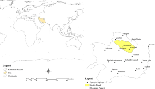
Synergistic approach for streamflow forecasting in a glacierized catchment of western Himalaya using earth observation and machine learning techniques

Enhancement of ANN performance for remote sensing rainfall estimate in northern Algeria using ensemble learning methods

Can geomorphic flood descriptors coupled with machine learning models enhance in quantifying flood risks over data-scarce catchments? Development of a hybrid framework for Ganga basin (India)
Data and material availability.
Not applicable.
Adhikary SK, Yilmaz AG, Muttil N (2015) Optimal design of rain gauge network in the Middle Yarra River catchment, Australia. Hydrol Process 29(11):2582–2599
Article Google Scholar
Agarwal A, Marwan N, Maheswaran R, Ozturk U, Kurths J, Merz B (2020) Optimal design of hydrometric station networks based on complex network analysis. Hydrol Earth Syst Sci 24(5):2235–2251
Aminyavari S, Saghafian B, Sharifi E (2019) Assessment of precipitation estimation from the NWP models and satellite products for the spring 2019 severe floods in Iran. Remote Sens 11(23):2741
Archer CL, Wu S, Ma Y, Jiménez PA (2020) Two corrections for turbulent kinetic energy generated by wind farms in the WRF model. Mon Weather Rev 148(12):4823–4835
Ayanwale OA, Alabi O (2017) Ground validation of GPM IMERG and TRMM 3B42V7 rainfall products over Nigerian eLightning. Paper presented at the AGU Fall Meeting 2019
Azamirad M, Esmaili K (2018) Investigation flooding potential in the Kashafrud watershed, Mashhad the method SCS and GIS. J Watershed Manag Res 9(17):26–38
Belabid N, Zhao F, Brocca L, Huang Y, Tan Y (2019) Near-real-time flood forecasting based on satellite precipitation products. Remote Sens 11(3):252
Benkirane M, Laftouhi N-E, Khabba S, Hera- Á (2022) Hydro statistical assessment of TRMM and GPM precipitation products against ground precipitation over a Mediterranean mountainous watershed (in the Moroccan high atlas). Appl Sci 12(16):8309
Article CAS Google Scholar
Boroujeni SMH (2019) Post disaster needs assessment (PDNA). J Disaster Emerg Res 2(2):124–125
Google Scholar
Cao Q, Mehran A, Lettenmaier DP, Mass C, Johnson N (2015) The utility of satellite precipitation products for hydrologic prediction in topographically complex regions: the Chehalis River Basin, WA as a case study. Paper presented at the AGU Fall Meeting Abstracts
Chao L, Zhang K, Yang Z-L, Wang J, Lin P, Liang J, Gu Z (2021) Improving flood simulation capability of the WRF-Hydro-RAPID model using a multi-source precipitation merging method. J Hydrol 592:125814
Chezgi J, Soheili E (2021) Application of TOPSIS and VIKOR decision making models in site selection of flood spreading projects in arid and semi-arid region. Desert Manag 8(16):169–182
Cloke H, Pappenberger F (2009) Ensemble flood forecasting: a review. J Hydrol 375(3–4):613–626
Cossu F, Hocke K (2014) Influence of microphysical schemes on atmospheric water in the weather research and forecasting model. Geosci Model Dev 7(1):147–160
Council AW (2009) Vulnerability of arid and semi-arid regions to climate change—impacts and adaptive strategies. Paper presented at the Perspective Document for the 5th World Water Forum, World Water Council, Marseille, Co-Operative Programme on Water and Climate (CPWC)
DeVries B, Huang C, Armston J, Huang W, Jones JW, Lang MW (2020) Rapid and robust monitoring of flood events using sentinel-1 and Landsat data on the google earth engine. Remote Sens Environ 240:111664
Dinku T, Funk C, Peterson P, Maidment R, Tadesse T, Gadain H, Ceccato P (2018) Validation of the CHIRPS satellite rainfall estimates over eastern Africa. Q J R Meteorol Soc 144:292–312
El Khalki EM, Tramblay Y, Amengual A, Homar V, Romero R, Saidi MEM, Alaouri M (2020) Validation of the AROME, ALADIN and WRF meteorological models for flood forecasting in Morocco. Water 12(2):437
ESCAP U (2019) Build a bridge on flood risk management: South-South and regional cooperation for flood risk management in the Islamic Republic of Iran
Falck A, Tomasella J, Papa F (2021) Assessing the potential of upcoming satellite altimeter missions in operational flood forecasting systems. Remote Sens 13(21):4459
Gao F, Zhang Y, Chen Q, Wang P, Yang H, Yao Y, Cai W (2018) Comparison of two long-term and high-resolution satellite precipitation datasets in Xinjiang, China. Atmos Res 212:150–157
Gorelick N, Hancher M, Dixon M, Ilyushchenko S, Thau D, Moore R (2017) Google earth engine: planetary-scale geospatial analysis for everyone. Remote Sens Environ 202:18–27
Guntu RK, Yeditha PK, Rathinasamy M, Perc M, Marwan N, Kurths J (2020) Wavelet entropy-based evaluation of intrinsic predictability of time series. Chaos: interdiscip J Nonlinear Sci 30(3):033117
Guo Q, Yang J, Wei C, Chen B, Wang X, Han C (2021) Spectrum calibration of the first hyperspectral infrared measurements from a geostationary platform: method and preliminary assessment. Q J R Meteorol Soc 147(736):1562–1583
Hasan MA, Islam A (2018) Evaluation of microphysics and cumulus schemes of WRF for forecasting of heavy monsoon rainfall over the southeastern hilly region of Bangladesh. Pure Appl Geophys 175(12):4537–4566
Hong Y, Gochis D, Cheng J-T, Hsu K-L, Sorooshian S (2007) Evaluation of PERSIANN-CCS rainfall measurement using the NAME event rain gauge network. J Hydrometeorol 8(3):469–482
Hong S-Y, Lim K-SS, Lee Y-H, Ha J-C, Kim H-W, Ham S-J, Dudhia J (2010) Evaluation of the WRF double-moment 6-class microphysics scheme for precipitating convection. Adv Meteorol. https://doi.org/10.1155/2010/707253
Hou S (2018) How does the evaluation of GPM IMERG rainfall product depend on gauge density and rainfall intensity? Paper presented at the AGU Fall Meeting Abstracts
Hu L, Nikolopoulos EI, Marra F, Morin E, Marani M, Anagnostou EN (2020) Evaluation of MEVD-based precipitation frequency analyses from quasi-global precipitation datasets against dense rain gauge networks. J Hydrol 590:125564
Jang S, Lim K-SS, Ko J, Kim K, Lee G, Cho S-J, Lee Y-H (2021) Revision of WDM7 microphysics scheme and evaluation for precipitating convection over the Korean Peninsula. Remote Sens 13(19):3860
Jung Y, Kim H, Baik J, Choi M (2014) Rain-gauge network evaluations using spatiotemporal correlation structure for semi-mountainous regions. TAO Terr, Atmos Ocean Sci 25(2):267
Kostarev S, Vetrov A (2018) Quality of precipitation prediction by the NWP model WRF-ARW with preliminary data assimilation. Paper presented at the IOP conference series: earth and environmental science
Krajewski W, Smith JA (2002) Radar hydrology: rainfall estimation. Adv Water Resour 25(8–12):1387–1394
Kreklow J, Tetzlaff B, Kuhnt G, Burkhard B (2019) A rainfall data intercomparison dataset of RADKLIM, RADOLAN, and rain gauge data for Germany. Data 4(3):118
Kumar L, Mutanga O (2018) Google earth engine applications since inception: usage, trends, and potential. Remote Sens 10(10):1509
Le Mire V, Boulanger X, Castanet L, Féral L (2023) Prediction of 3 years of annual rain attenuation statistics at Ka-band in French Guiana using the numerical weather prediction model WRF. Radio Sci 58(6):1–10
Li Y, Grimaldi S, Walker JP, Pauwels VR (2016) Application of remote sensing data to constrain operational rainfall-driven flood forecasting: a review. Remote Sens 8(6):456
Li H, Zhou Y, Wang X, Zhou X, Zhang H, Sodoudi S (2019) Quantifying urban heat island intensity and its physical mechanism using WRF/UCM. Sci Total Environ 650:3110–3119
Liu J, Bray M, Han D (2012) Sensitivity of the Weather Research and Forecasting (WRF) model to downscaling ratios and storm types in rainfall simulation. Hydrol Process 26(20):3012–3031
Liu YC, Zhao K, Liu Y, Yin XL (2018) Analysis of the impact of precipitation and temperature on the streamflow of the Ürümqi River, Tianshan Mountain, China. Paper presented at the IOP conference series: earth and environmental science
Lowrey MRK, Yang Z-L (2008) Assessing the capability of a regional-scale weather model to simulate extreme precipitation patterns and flooding in central Texas. Weather Forecast 23(6):1102–1126
Lu Q, Hu J, Wu C, Qi C, Wu S, Xu N (2020) Monitoring the performance of the Fengyun satellite instruments using radiative transfer models and NWP fields. J Quant Spectrosc Radiat Transfer 255:107239
Maggioni E, Manzoni T, Perotto A, Spada F, Borroni A, Giurato M, Salerno R (2023) WRF data assimilation of weather stations and lightning data for a convective event in northern Italy. Bull Atmos Sci Technol 4(1):8
Mane D, Chandrasekar A (2022) Evaluation of a stand-alone WRF-hydro modeling system using different rainfall forcing data: case study over the Godavari river basin, India. Pure Appl Geophys. https://doi.org/10.1007/s00024-022-03136-3
Massari C, Camici S, Ciabatta L, Brocca L (2018) Exploiting satellite-based surface soil moisture for flood forecasting in the Mediterranean area: state update versus rainfall correction. Remote Sens 10(2):292
Mayer MJ, Yang D (2022) Calibration of deterministic NWP forecasts and its impact on verification. Int J Forecasting. 39(2):981–991
Mohammadiha A, Memarian M, Azadi M, Parvari R (2012) Verification of WRF Model forecatings for content of precipitable water and precipitation with the RADAR data. Thesis submitted For the degree of M.Sc, pp 1–160
Moishin M, Deo RC, Prasad R, Raj N, Abdulla S (2021) Designing deep-based learning flood forecast model with ConvLSTM hybrid algorithm. IEEE Access 9:50982–50993
Moradkhani H, DeChant CM, Sorooshian S (2012) Evolution of ensemble data assimilation for uncertainty quantification using the particle filter-Markov chain Monte Carlo method. Water Resour Res. https://doi.org/10.1029/2012WR012144
Nabinejad S, Schüttrumpf H (2023) Flood risk management in arid and semi-arid areas: a comprehensive review of challenges, needs, and opportunities. Water 15(17):3113
Nasrollahi N, AghaKouchak A, Li J, Gao X, Hsu K, Sorooshian S (2012) Assessing the impacts of different WRF precipitation physics in hurricane simulations. Weather Forecast 27(4):1003–1016
Nikolopoulos EI (2010) Flash floods: understanding the runoff generation processes and the use of satellite-rainfall in hydrologic simulations: University of Connecticut
Pan S, Xu Y-P, Gu H, Bai Z, Xuan W (2021) Temporary dependency of parameter sensitivity for different flood types. Hydrol Res 52(5):990–1014
Putthividhya A, Tanaka K (2012) Optimal rain gauge network design and spatial precipitation mapping based on geostatistical analysis from colocated elevation and humidity data. Int J Environ Sci Dev 3(2):124
Rahman MM, Singh Arya D, Goel NK, Mitra AK (2012) Rainfall statistics evaluation of ECMWF model and TRMM data over Bangladesh for flood related studies. Meteorol Appl 19(4):501–512
Ramadhan R, Marzuki M, Yusnaini H, Ningsih AP, Hashiguchi H, Shimomai T (2022) Ground validation of GPM IMERG-F precipitation products with the point rain gauge records on the extreme rainfall over a mountainous area of Sumatra Island. Jurnal Penelitian Pendidikan IPA 8(1):163–170
Roy A, Thakur PK, Nikam BR (2018). Evaluation of high resolution gridded precipitation products and comparison with the simulated precipitation obtained from WRF model in regions of North Western Himalaya. 42nd COSPAR Scientific Assembly. Vol 42, pp A3. 1–21–18
Sättele M, Bründl M, Straub D (2015) Reliability and effectiveness of early warning systems for natural hazards: concept and application to debris flow warning. Reliab Eng Syst Saf 142:192–202
Sharafati A, Pezeshki E (2020) A strategy to assess the uncertainty of a climate change impact on extreme hydrological events in the semi-arid Dehbar catchment in Iran. Theoret Appl Climatol 139(1):389–402
Shorabeh SN, Firozjaei MK, Nematollahi O, Firozjaei HK, Jelokhani-Niaraki M (2019) A risk-based multi-criteria spatial decision analysis for solar power plant site selection in different climates: a case study in Iran. Renewable Energy 143:958–973
Skamarock WC, Klemp JB, Dudhia J, Gill DO, Barker DM, Duda MG, Huang XY, Wang W, Powers JG (2008) A description of the advanced research WRF version 3. NCAR Technical Note 475:113
Spiridonov V, Baez J, Telenta B, Jakimovski B (2020) Prediction of extreme convective rainfall intensities using a free-running 3-D sub-km-scale cloud model initialized from WRF km-scale NWP forecasts. J Atmos Solar Terr Phys 209:105401
Sulugodu B, Deka PC (2019) Evaluating the performance of CHIRPS satellite rainfall data for streamflow forecasting. Water Resour Manag 33(11):3913–3927
Tian F, Hou S, Yang L, Hu H, Hou A (2018) How does the evaluation of the GPM IMERG rainfall product depend on gauge density and rainfall intensity? J Hydrometeorol 19(2):339–349
Tiwari S, Jha SK, Singh A (2020) Quantification of node importance in rain gauge network: influence of temporal resolution and rain gauge density. Sci Rep 10(1):1–17
Toosi AS, Doulabian S, Tousi EG, Calbimonte GH, Alaghmand S (2020) Large-scale flood hazard assessment under climate change: a case study. Ecol Eng 147:105765
Tripathy P, Malladi T (2022) Global flood mapper: a novel google earth engine application for rapid flood mapping using sentinel-1 SAR. Nat Hazards 114(2):1341–1363
Usowicz B, Lipiec J, Łukowski M, Słomiński J (2021) Improvement of spatial interpolation of precipitation distribution using cokriging incorporating rain-gauge and satellite (SMOS) soil moisture data. Remote Sens 13(5):1039
Wagner S, Fersch B, Yuan F, Yu Z, Kunstmann H (2016) Fully coupled atmospheric-hydrological modeling at regional and long-term scales: Development, application, and analysis of WRF-HMS. Water Resour Res 52(4):3187–3211
Wanzala MA, Stephens EM, Cloke HL, Ficchi A (2022) Hydrological model preselection with a filter sequence for the national flood forecasting system in Kenya. J Flood Risk Manag. https://doi.org/10.1111/jfr3.12846
Worqlul AW, Yen H, Collick AS, Tilahun SA, Langan S, Steenhuis TS (2017) Evaluation of CFSR, TMPA 3B42 and ground-based rainfall data as input for hydrological models, in data-scarce regions: The upper Blue Nile Basin, Ethiopia. CATENA 152:242–251
Xu R, Tian F, Yang L, Hu H, Lu H, Hou A (2017) Ground validation of GPM IMERG and TRMM 3B42V7 rainfall products over southern Tibetan Plateau based on a high-density rain gauge network. J GeophysRes: Atmos 122(2):910–924
Xu W, Liu P, Cheng L, Zhou Y, Xia Q, Gong Y, Liu Y (2021) Multi-step wind speed prediction by combining a WRF simulation and an error correction strategy. Renew Energy 163:772–782
Yeditha PK, Kasi V, Rathinasamy M, Agarwal A (2020) Forecasting of extreme flood events using different satellite precipitation products and wavelet-based machine learning methods. Chaos: Interdiscip J Nonlinear Sci 30(6):063115
Yuan Y, Wang R, Cooter E, Ran L, Daggupati P, Yang D, Jalowska A (2018) Integrating multimedia models to assess nitrogen losses from the Mississippi River basin to the Gulf of Mexico. Biogeosciences 15(23):7059–7076
Zabihi O, Gheibi M, Aghlmand R, Nejatianc A (2022) Scrutinizing famine disaster based on rainfall trend investigation (a case study of Khorasan Razavi province). J Water 1(2):17–26
Zhang L, He C, Tian W, Zhu Y (2021) Evaluation of precipitation datasets from TRMM satellite and down-scaled reanalysis products with bias-correction in middle Qilian Mountain, China. Chin Geogrl Sci 31(3):474–490
Zhang L, Gong S, Zhao T, Zhou C, Wang Y, Li J (2021) Development of WRF/CUACE v1. 0 model and its preliminary application in simulating air quality in China. Geosci Model Dev 14(2):703–718
Zhang T, Yang Y, Dong Z, Gui S (2021) A multiscale assessment of three satellite precipitation products (TRMM, CMORPH, and PERSIANN) in the three Gorges reservoir area in China. Adv Meteorol. https://doi.org/10.1155/2021/9979216
Zhang Y, Hou J, Huang C, You Y (2019) Coupling WRF and grid SWAT for ultra-high resolution hydrologic modelling. Paper presented at the geophysical research abstracts
Download references
This Paper is a part of the elite soldier project of Iran, and it has been done with the financial support Regional Water Company of Khorasan Razavi.
Author information
Authors and affiliations.
Department of Climatology, Faculty of Geography and Environmental Sciences, Hakim Sabzevari University, Sabzevar, Iran
Rasoul Sarvestan
Applied Research Department, Khorasan Razavi Regional Water Company, Mashhad, Iran
Reza Barati
Climatology, Department of Physical Geography, Faculty of Geography, University of Tehran, Tehran, Iran
Aliakbar Shamsipour
Irrigation and drainage, Office of basic studies of water resources, Regional water company of khorasan razavi, Mashhad, Iran
Sahar Khazaei
University of Innsbruck, Innsbruck, Austria
Manfred Kleidorfer
You can also search for this author in PubMed Google Scholar
Contributions
All authors contributed to the study's conception and design. Material preparation, data collection, and analysis were performed by Rasoul Sarvestan, Reza Barati, Aliakbar Shamsipour, Sahar Khazaei and Manfred Kleidorfer. The first draft of the manuscript was written by Rasoul Sarvestan and all authors commented on previous versions of the manuscript. All authors read and approved the final manuscript.
Corresponding author
Correspondence to Rasoul Sarvestan .
Ethics declarations
Conflict of interest.
The authors have no conflicts of interest to declare that they are relevant to the content of this article.
Ethical approval and consent to participate
Consent for publication, additional information, publisher's note.
Springer Nature remains neutral with regard to jurisdictional claims in published maps and institutional affiliations.
Rights and permissions
Springer Nature or its licensor (e.g. a society or other partner) holds exclusive rights to this article under a publishing agreement with the author(s) or other rightsholder(s); author self-archiving of the accepted manuscript version of this article is solely governed by the terms of such publishing agreement and applicable law.
Reprints and permissions
About this article
Sarvestan, R., Barati, R., Shamsipour, A. et al. Evaluation of the performance of satellite products and microphysical schemes with the aim of forecasting early flood warnings in arid and semi-arid regions (a case study of northeastern Iran). Nat Hazards (2024). https://doi.org/10.1007/s11069-024-06689-9
Download citation
Received : 30 October 2023
Accepted : 12 May 2024
Published : 24 May 2024
DOI : https://doi.org/10.1007/s11069-024-06689-9
Share this article
Anyone you share the following link with will be able to read this content:
Sorry, a shareable link is not currently available for this article.
Provided by the Springer Nature SharedIt content-sharing initiative
- Precipitation
- Satellite products
- Warning forecast
- Find a journal
- Publish with us
- Track your research
IMAGES
VIDEO
COMMENTS
Effects. In some areas, floodwater was between 3-4.5m deep. Floods in the southern Indian state of Kerala have killed more than 410 people since June 2018 in what local officials said was the worst flooding in 100 years. Many of those who died had been crushed under debris caused by landslides.
Sst Class9 Disaster Management Project - Free download as PDF File (.pdf), Text File (.txt) or read online for free. This document is a student project on disaster management. It begins with an introduction that defines what a disaster is and lists several types of disasters such as earthquakes, tsunamis, cyclones, epidemics, floods, droughts, landslides, and industrial hazards.
Students in class IX are required to submit a handwritten project on disaster management as required by the CBSE. The subjects will come from the school. The topic could be either natural disasters or man-made disasters. The purpose of assigning this disaster management homework to class 9 students is to get them ready for any disaster.
Types of Disaster for Class 9 Students. Disasters are categorised into the following types-. Floods, hail storms, cloudbursts, cyclones, heat waves, cold waves, droughts, and hurricanes are all examples of water-related disasters. Landslides, earthquakes, volcanic eruptions, and tornadoes are examples of geological disasters.
Oct 19, 2021. Manimalayar witnesses biggest flood in 64 years. Being a coastal state of India and much of the land being part of the fragile Western Ghats, Kerala is very sensitive to climate ...
FLOOD A flood is an overflow of an expanse of water that submerges land. Flood is defined as a covering by water of land which is not normally covered by water. In the sense of "flowing water", the word may also be applied to the inflow of the tide. Flooding may result from the volume of water within a body of water, such as a river or lake, which
On 16 August 2018, severe floods affected the south Indian state Kerala, due to unusually heavy rainfall during the monsoon season. [3] [4] [5] It was the worst flood in Kerala in nearly a century. [6] Over 483 people died, and 15 went missing. [7] About a million [8] [9] people were evacuated, mainly from Chengannur, [10] Pandanad, [11] Edanad ...
Beginning on August 15th 2018, severe floods were affected in Kerala due to unusually high rain fall during the monsoon season. It was the worst flooding in Kerala nearly a century. Almost 370 people died and 33000 peoples are rescued. According to Kerala Govt. one sixth of the total population of Kerala had been directly affected by flood.
UNIT. IV. Y. ou might have read about tsunami or seen the images of horror on television set immediately after it happened. Y ou may also be awar e of the sever e earthquake in Kashmir on both sides of the Line of Control (LOC). The damage caused to human life and properties during these episodes has moved us all.
Detailed explanation with examples on all-about-floods helps you to understand easily , designed as per NCERT. QnA , Notes & Videos
1-day m aximum rainfall aver aged over the entire state in August 2018 had a return period of ab out 75 years. However, 2 and 3-day maximum rainfall had the return per iod of about 200 and 100 ...
Flood management played an important role in Kerala 2018 floods. The Disaster Management strategies include Mitigation, Preparedness, Rescue and Recovery. Through this study, we would like to suggest that the Sponge Cities and Flood Resistant Buildings are the most appropriate Risk reducing Strategies, which can reduce Flood hazard risk
Disaster management is the practice of trying to prevent or reduce damage, injury, or death resulting from natural or man-made disasters. There are different levels of levels of disaster management. The 4 levels of disaster management are mitigation, preparedness, response, and recovery. See also The Happy Prince Summary (CBSE Class 9) By Oscar ...
Case Study Questions for Class 9 Social Science Geography Chapter 3 Drainage. Case Study Questions. ... They are the rivers, which flood parts of the northern plains every year, causing widespread damage to life and property but enriching the soil for the extensive agricultural lands. The main tributaries, which come from the peninsular uplands ...
Feb 5, 2016 • Download as PPTX, PDF •. 13 likes • 16,129 views. A. ankitkalariya. flood project case study rku projrct seminar. Read more. Engineering. Download now. Flood project case study rk - Download as a PDF or view online for free.
Disaster management with case study - Download as a PDF or view online for free. ... Sst class 9 becoming a disaster management Rajat Gupta ... on 7 September, 14, the third day of incessant rains, when flood waters breached the banks of Jhelum, and submerged Srinagar, including the Badami Bagh Cantonment, disrupted " electricity, water ...
Definition and Mitigation - Disaster Management Class 9. Floods are the most common and widespread of all-natural disasters. India is one of the highly flood-prone countries in the world. Around 40 million hectares of land in India are prone to floods as per the National Flood Commission report. Floods cause damage to houses, industries, public ...
project-flood & disaster management - Free download as Word Doc (.doc / .docx), PDF File (.pdf), Text File (.txt) or read online for free. 1. The document discusses floods and droughts in India, including their causes, impacts, and mitigation measures. It provides details on regions prone to floods and droughts. 2. Major causes of floods include heavy rainfall, siltation of river beds ...
City planners prioritize outreach and engagement so that residents know about flood risk and prevention. These outreach efforts have helped Tulsa earn the highest rating in FEMA's CRS. The CRS Class 1 designation means that Tulsa residents receive a 45% discount on their flood insurance policies. Tulsa is one of only two communities in the ...
These case studies were essential in formulating the Integrated Flood Management concepts, as they helped to: Identify the institutional changes required to achieve IFM. The case studies are presented here for "historical purposes": having been compiled almost 20 years ago, they are reflecting national situations that might since have ...
Results: 234 persons died and over 800 were reported missing. Almost half of the people who died were local residents (49.6%) and foreigners (10.2%). Age-wise analysis of the deaths shows that the majority of deaths were reported in the age group of 25-50 years, accounting for 44.4% of deaths, followed by the 11-25-year age group with 22.2% ...
Flood vulnerability assessment (FVA) informs the disaster risk reduction and preparedness process in both rural and urban areas. However, many flood-vulnerable regions like Malawi still lack FVA supporting frameworks in all phases (pre-trans-post disaster). Partly, this is attributed to lack of the evidence-based studies to inform the processes. This study was therefore aimed at assessing ...
Ideal site downstream of Chongqing, as valley is narrow but reservoir big. 660km long and 1km wide reservoir. Completed in 2009, wall is 2.3 km long, 200m high. $38bn to build, 18,000 mW HEP station. Best free resources for CAIE AS LEVEL Geography 9696 Case Studies including summarized notes, topical and past paper walk through videos by top ...
Flood early warning requires rainfall data with a high temporal and spatial resolution for flood risk analysis to simulate flood dynamics in all small and large basins. However, such high-quality data are still very scarce in many developing countries. In this research, in order to identify the best and most up-to-date rainfall estimation tools for early flood forecasting in arid and semi-arid ...